Τετάρτη 9 Φεβρουαρίου 2011

Magnetic Polar Shifts Causing Massive Global Superstorms

Superstorms can also cause certain societies, cultures or whole countries to collapse. Others may go to war with each other.
Superstorm
Courtesy: Weather Snob

(CHICAGO) - NASA has been warning about it…scientific papers have been written about it…geologists have seen its traces in rock strata and ice core samples…
Now "it" is here: an unstoppable magnetic pole shift that has sped up and is causing life-threatening havoc with the world's weather.
Forget about global warming—man-made or natural—what drives planetary weather patterns is the climate and what drives the climate is the sun's magnetosphere and its electromagnetic interaction with a planet's own magnetic field.
When the field shifts, when it fluctuates, when it goes into flux and begins to become unstable anything can happen. And what normally happens is that all hell breaks loose.
Magnetic polar shifts have occurred many times in Earth's history. It's happening again now to every planet in the solar system including Earth.
The magnetic field drives weather to a significant degree and when that field starts migrating superstorms start erupting.
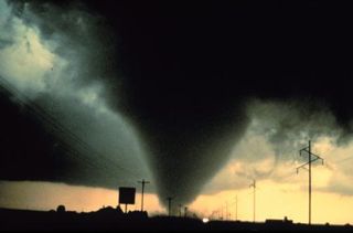
The superstorms have arrived
The first evidence we have that the dangerous superstorm cycle has started is the devastating series of storms that pounded the UK during late 2010.
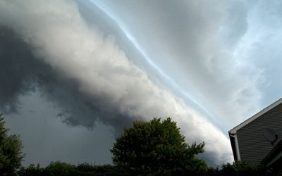
On the heels of the lashing the British Isles sustained, monster storms began to lash North America. The latest superstorm — as of this writing — is a monster over the U.S. that stretched across 2,000 miles affecting more than 150 million people.
Yet even as that storm wreaked havoc across the Western, Southern, Midwestern and Northeastern states, another superstorm broke out in the Pacific and closed in on Australia.
The southern continent had already dealt with the disaster of historic superstorm flooding from rains that dropped as much as several feet in a matter of hours. Tens of thousands of homes were damaged or destroyed. After the deluge tiger sharks were spotted swimming between houses in what was once a quiet suburban neighborhood.
Shocked authorities now numbly concede that much of the water may never dissipate and have wearily resigned themselves to the possibility that region will now contain a new inland sea.
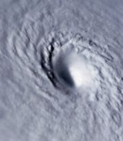
But then only a handful of weeks later another superstorm; the megamonster cyclone Yasi, struck northeastern Australia. The damage it left in its wake is being called by rescue workers a war zone.
The incredible superstorm packed winds near 190mph. Although labeled as a category-5 cyclone, it was theoretically a category-6. The reason for that is storms with winds of 155mph are considered category-5, yet Yasi was almost 22 percent stronger than that.

Source: http://www.salem-news.com/articles/february042011/global-superstorms-ta.php

Τρίτη 8 Φεβρουαρίου 2011

Will Apophis Hit Earth in 2036? NASA Rejects Russian Report

In 2004, NASA scientists announced that there was a chance that Apophis, an asteroid larger than two football fields, could smash into Earth in 2029. A few additional observations and some number-crunching later, astronomers noted that the chance of the planet-killer hitting Earth in 2029 was nearly zilch.
Now, reports out of Russia say that scientists there estimate Apophis will collide with Earth on April 13, 2036. These reports conflict on the probability of such a doomsday event, but the question remains: How scared should we be?
“Technically, they’re correct, there is a chance in 2036 [that Apophis will hit Earth]," said Donald Yeomans, head of NASA’s Near-Earth Object Program Office. However, that chance is just 1-in-250,000, Yeomans said.
The Russian scientists are basing their predictions of a collision on the chance that the 900-foot-long (270 meters) Apophis will travel through what’s called a gravitational keyhole as it passes by Earth in 2029. The gravitational keyhole they mention is a precise region in space, only slightly larger than the asteroid itself, in which the effect of Earth's gravity is such that it could tweak Apophis' path.
“The situation is that in 2029, April 13, [Apophis] flies very close to the Earth, within five Earth radii, so that will be quite an event, but we’ve already ruled out the possibility of it hitting at that time,” Yeomans told Life’s Little Mysteries. “On the other hand, if it goes through what we call a keyhole during that close Earth approach … then it will indeed be perturbed just right so that it will come back and smack Earth on April 13, 2036,” Yeomans said.
The chances of the asteroid going through the keyhole, which is tiny compared to the asteroid, are “minuscule,” Yeomans added.
The more likely scenario is this: Apophis will make a fairly close approach to Earth in late 2012 and early 2013, and will be extensively observed with ground-based optical telescopes and radar systems. If it seems to be heading on a destructive path, NASA will devise the scheme and machinery necessary to change the asteroid’s orbit, decreasing the probability of a collision in 2036 to zero, Yeomans said.
There are several ways to change an asteroid’s orbit, the simplest of which is to run a spacecraft into the hurtling rock. This technology was used on July 4, 2005, when Deep Impact smashed into the comet Tempel 1.
This story was provided by Life's Little Mysteries, a sister site of SPACE.com.

Source: http://news.yahoo.com/s/space/20110207/sc_space/willapophishitearthin2036nasarejectsrussianreport;_ylt=AnUwNIehqjJnzwvj_lrED.ys0NUE;_ylu=X3oDMTNoMGNsMWtqBGFzc2V0A3NwYWNlLzIwMTEwMjA3L3dpbGxhcG9waGlzaGl0ZWFydGhpbjIwMzZuYXNhcmVqZWN0c3J1c3NpYW5yZXBvcnQEcG9zAzgEc2VjA3luX21vc3RfcG9wdWxhcgRzbGsDd2lsbGFwb3BoaXNo

Σάββατο 5 Φεβρουαρίου 2011

Torrential downpours pile misery on Australia

TULLY HEADS, Australia (AFP) – Torrential rains and flash floods trapped scores of people in homes and cars following a massive cyclone, piling more misery on Australia Saturday after weeks of record inundations.
As coastal residents pieced together homes and farms destroyed by Severe Tropical Cyclone Yasi, dramatic deluges brought by cyclone activity caused chaos in the state of Victoria, some 2,000 kilometres (1,200 miles) away.
Authorities urged residents of the small town of Koo Wee Rup, southeast of Melbourne, to evacuate for fear of flash floods, while more than 80 people were rescued from flood-bound houses and vehicles.
An English tourist, 26, was in critical condition with serious head injuries after a gum tree came down on her tent, and a 14-year-old girl was pulled from a swollen river. Emergency services fielded thousands of calls for help.
"There is a simple message for everybody in Victoria at the moment: please take care," warned Victoria state premier Ted Baillieu.
"Whether you're near the roads, whether you're near floodwaters, please don't drive through, ride through or play through floodwaters."
Parts of Melbourne, Australia's second biggest city, were lashed by 175 millimetres (6.8 inches) of rain overnight, while flash floods hit the town of Mildura after a record downpour of 200 millimetres on Friday afternoon.
The rains come in the wake of Australia's worst cyclone in a century, which left a trail of destruction and a damage bill of billions of dollars (billions US) after hitting Queensland state on Wednesday, but miraculously caused no known deaths.
The category five storm -- the highest level -- laid waste to entire towns, hurled luxury yachts around like toys and shredded enormous swathes of banana and sugar crops, adding an estimated 0.25 percentage points to inflation.
"I'm amazed we survived it," said banana farmer Daryl Webber, 42, who stood in his house as the roof was torn off, the windows were blown out and walls fell apart.
"The whole house was shaking, (wall) panels were flying everywhere. It was just horrendous. You wouldn't believe the force of the winds," he told AFP.
The remains of homes and debris including fridges and pool tables littered the devastated coastal hamlet of Tully Heads, while some communities remained cut off by floods and fallen trees, hampering recovery efforts.
Two men who were reported missing turned up safe, along with a couple who were feared drowned after their yacht capsized and a teenager who jumped into a fast-flowing river to save his dog. The pet also survived.
Looters stole thousands of dollars' (thousands US) worth of stock from a cyclone-hit Queensland pub, making off with its store of beer and the spirits from behind the bar.
"I think it is terrible that people take advantage in these situations. You lose faith in humans," staff member Janet Lobegeier said.
Australia's military scaled back operations to deal with weeks of floods, which affected three-quarters of Queensland, including the state capital Brisbane. But another 4,000 troops were helping clear up after the cyclone.
Swiss miner Xstrata resumed its operations at Mount Isa and Cloncurry, in Queensland's north, after the downgraded storm failed to cause any damage.
Power was restored to 15,000 properties in tourist centre Cairns, a gateway to the Great Barrier Reef, as military aircraft prepared to fly in bottled water, tinned food and baby supplies because some roads remained impassable.
Tully Heads, which was virtually wiped off the map, was closed to the public and media as dazed residents wondered how to rebuild their lives with no homes, no power and little fuel and food.
Many people are living in patched-up homes with gaping holes covered by tarpaulin, and surviving hand-to-mouth until help arrives. Meanwhile, the local agricultural industry is in ruins.
"People say good old Queenslanders are tough and they can rebuild, but this is just too hard for us," said elderly resident Sandra Cameron.

Source: http://news.yahoo.com/s/afp/20110205/wl_asia_afp/australiaweatherstorm;_ylt=ArWO58kjIwWlyPzMIQVdtuRoWrEF;_ylu=X3oDMTJzMjZkanE0BGFzc2V0A2FmcC8yMDExMDIwNS9hdXN0cmFsaWF3ZWF0aGVyc3Rvcm0EcG9zAzQEc2VjA3luX3BhZ2luYXRlX3N1bW1hcnlfbGlzdARzbGsDdG9ycmVudGlhbGRv

Παρασκευή 4 Φεβρουαρίου 2011

Πρόγνωση καιρού Αττικής - Θεσσαλονίκης 5-8/01/2011

Βελτίωση του καιρού στην Αττική , παραμένει αίθριος στην Θεσσαλονίκη που έμεινε ανεπηρέαστη από το σύστημα των 2 τελευταίων ημερών. Βελτιωμένος ο καιρός τις προσεχείς ημέρες.

Αναλυτικά η πρόγνωση για το Σαββατοκύριακο, την Δευτέρα και την Τρίτη.


Σάββατο 5 Φεβρουαρίου

Αττική: Αρχικά λίγες νεφώσεις παροδικά αυξημένες τις πρωινές ώρες στα βόρεια και ανατολικά του νομού. Καθαρός ουρανός για το υπόλοιπο της ημέρας. Άνεμοι βορειοανατολικοί 4-6 και στα ανατολικά πρόσκαιρα ,έως το μεσημέρι, μέχρι 7 μποφόρ με σταδιακή εξασθένηση από το μεσημέρι και μετά. Θερμοκρασία από 2 έως 13 βαθμούς Κελσίου.

Θεσσαλονίκη: Σχεδόν αίθριος καιρός. Άνεμοι από βόρειες-βορειοανατολικές διευθύνσεις ασθενείς και πρόσκαιρα μέχρι 4 μποφόρ. Θερμοκρασία σε χαμηλά επίπεδα με παγετό την νύχτα και νωρίς το πρωί, θα κυμανθεί από -1 έως 9 τοπικά και 10 βαθμούς. Να σημειώσουμε πως ο παγετός και οι αρνητικές θερμοκρασίες θα σημειωθούν κυρίως στο εσωτερικο του νομού. Στο κέντρο η ελάχιστη θα πλησιάσει τους 0 βαθμούς κελσίου.


Κυριακή 6 Φεβρουαρίου

Αττική: Γενικά αίθριος καιρός. Άνεμοι βορειοανατολικοί μέτριοι 3-4 και στα ανατολικά μέχρι 5 μποφόρ. Θερμοκρασία από 1 έως 15 βαθμούς Κελσίου.

Θεσσαλονίκη: Γενικά αίθριος καιρός. Άνεμοι ασθενείς 2-3 μποφόρ από βόρειες-βορειοανατολικές διευθύνσεις κυρίως. Θερμοκρασία από 1 έως 12 βαθμούς Κελσίου. Παγετός και πάλι στο εσωτερικό του νομού.


Δευτέρα 7 Φεβρουαρίου

Αττική: Και πάλι γενικά αίθριος καιρός. Άνεμοι βορειοανατολικοί ασθενείς μέχρι μέτριοι 3-4 και στα αντολικά έως 5 μποφόρ. Θερμοκρασία σε αισθητή άνοδο την ημέρα, θα κυμανθεί από 2 έως 17 βαθμούς Κερλσίου.

Θεσσαλονίκη: Αίθριος καιρός με πιθανότητα για τοπικές ομίχλες τις πρωινές κυρίως ώρες στα ημιορεινά ανατολικά τμήματα. Άνεμοι ασθενείς έως μεταβλητοί 2-3 μποφόρ. Θερμοκρασία από 2 έως 14 τοπικά και 15 βαθμούς Κελσίου.


Τρίτη 8 Φεβρουαρίου

Αττική: Γενικα καλός με λίγες τοπικές νεφώσεις στα βόρεια και ανατολικά κυρίως ορεινά τμήματα. Άνεμοι 4-5 και στα ανατολικά έως 6 μποφόρ από βόρειες-βορειοανατολικές διευθύνσεις. Θερμοκρασία σε μικρή πτώση, θα κυμανθεί από 3 έως 15 βαθμούς Κελσίου.

Θεσσαλονίκη: Λίγες αραιές νεφώσεις κατά περιόδους. Άνεμοι ανατολικοί-βορειοανατολικοί 3-4 μποφόρ. Θερμοκρασία από 1 έως 13 βαθμούς Κελσίου. Πιθανόν παγετός στο εσωτερικό του νομού και στα ορεινά ημιορεινά τμήματα.


Αλλαγή του καιρού και πάλι με βροχές κυρίως στην κεντρική και νότια χώρα, αναμένεται από την Τετάρτη και από τα νοτιοδυτικα. Λεπτομέρειες σε επόμενα άρθρα.

Επιμέλεια Άρθρου :  Άκης Λ.


Πηγή: http://kairos1.blogspot.com/ 

Πέμπτη 3 Φεβρουαρίου 2011

8 χωριά αποκλεισμένα στην Αργολίδα

Αποκλεισμένα από την κακοκαιρία δηλαδή από την χιονόπτωση Νιοχώρι ,Φρουσιούνα,Δούκα Βρύση, Κεφαλόβρυσο, Εξοχή,Αλέα,Σκοτεινή,Άγιος Νικόλαος στο Νομό Αργολίδας


Πηγή: http://www.parapolitikaargolida.gr/2011/02/8.html